![]()
![]()
![]()
|
|
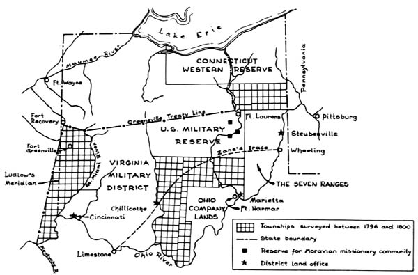
GREENVILLE & GROUSELAND TREATY LINES by Roger Woodfill In 1796 a new democracy, desperately poor, passed a Land Act, entitled: "An Act providing for the Sale of the lands of the United States, in the territory north-west of the river Ohio and above the mouth of the Kentucky river". (This same land was won from the French in the French and Indian War, relinquished by the British in the Treaty of Paris, and appropriated from the Native Americans through years of battles and negotiations). Its provisions created the office of Surveyor General, established the rectangular system, decreed standards of land measurement, mandated recordkeeping and dictated the base pay of deputy surveyors, their chain carriers and axemen. Under the new law, President Washington appointed the former Revolutionary War Brigadier General of the Army Engineers, Rufus Putnam, as the first federal Surveyor General. Putnam's first order of business was to establish a field office in Marietta, Ohio, and to hire surveyors to measure the Greenville Treaty Line. The Treaty was the result of General "Mad Anthony" Wayne's victory over the Native American tribes who defended their lands in "The Battle of Fallen Timbers", August 1794. The Treaty "guaranteed that the American settlement in Northwest Territory was secure from Indian attack as far west as a line that met the Ohio River at a point opposite the mouth of the Kentucky river".
Apparently, when Freeman was nearly finished with the survey, the United States went back to before the French title and bought the land from the true original owners - the Indians. Because of this precaution, any doubt about the title was cleared away." The northeast corner of the Vincennes Tract became known as "Freeman's Corner" and was the starting point for the 1805 "Treaty of Grouseland". Negotiated by then-Governor of the Indiana Territory William Henry Harrison, the treaty gained more land from the Indians. The line ran northeasterly to intersect a point on the Greenville Treaty Line fifty miles north of the Ohio River. Arthur Henri, a United States Deputy Surveyor, was given this assignment. In July 1806 he started running a line N 65 00' 00" E from Freeman's Corner toward present day Brookville, Indiana. Eighty miles and 38 chains (2508 feet) later, he crossed the line Ludlow had cut a decade earlier, but he was fifteen miles too far south. He moved up Ludlow's line to the fifty mile post and started back. Eighty-nine miles later, he crossed a Vincennes Tract line. Again returning to Freeman's Corner, he proceeded easterly toward Brookville at N57 00' 00" E correcting his second line to the true treaty line, and referencing his mile posts. Henri's field notes show that he ceased witnessing his new points at mile number sixty-eight. (He probably intersected his second line near there). Henri also lists the deviation of his magnetic compass from true north at three points along the line. Therefore it would not be surprising if deflections exist in the Grouseland Treaty Line between sixty and seventy miles from Freeman's Corner. Today it still serves as a county line between Ripley and Decatur Counties, as well as a boundary for numerous private holdings. Deputy Surveyors Ludlow, Freeman, and Henri were trailblazers; their surveys opened up treaty lands for settlement which ultimately led to Ohio's statehood in 1803, and Indiana's in 1819. The Indiana Surveyors Historical Society in conjunction with the Franklin County (IN) Historical Society completed a two year project to locate and remonument the intersection point of the Greenville Treaty Line (1795) and the Grouseland Treaty Line (1805). A public ceremony was held, where an Indiana Historical Society marker and the monument at the intersection site were both unveiled for the first time.
|
|
|