|
 Article taken from "Backsights"
Magazine published by Surveyors Historical Society
|
A
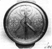
SURVEYORS COMPASS MADE BY GOLDSMITH CHANDLEE
Reprinted
from Rittenhouse magazine, Vol. 2, No. 3, May 1988
A surveyor’s plain compass made in
Winchester, Virginia around 1800 has recently surfaced in Portland, Oregon. The
compass was made by Goldsmith Chandlee (ca. 1746-1821), a prolific maker of
mathematical instruments, clocks, sundials, telescopes, steelyards and other
scales, and surgical instruments. Born to a Quaker family, Chandlee apprenticed
with his father, the clockmaker Benjamin Chandlee, Jr. in Nottingham, Maryland.
In 1775 he moved to Virginia, worked with the silversmith William Richardson,
and then established his own brass foundry and shop.1
 The
face of this compass has two circular dials, controlled by knobs under the
compass box, which were used to keep track of the linear distances surveyed. The
dial at the western point is labeled "P" and that at the eastern point
is labeled "M." The "P" (for "pole") dial appears
on every Chandlee compass that has been published or is available in a public
collection.² The "P" dial is graduated into 320
parts in divisions of 20, and numbered every 40 divisions (40 poles = 1 furlong,
320 poles = 1 mile). Within the "P" dial is a window that reveals the
outkeeper, recording numbers from 1 to 16 on a revolving wheel set below the
compass face. This was used to count the number of 5-chains that had been run (5
chains = 20 poles; 16 X 5 chains = 320 poles = 1 mile). The "M" dial
is graduated into 21 parts, and numbered every 3 divisions. Its tiny gold clock
hand has a non-reversible counterclockwise motion. The "M" dial, which
was probably used to record the miles, has been found on only two other
compasses.³ The
face of this compass has two circular dials, controlled by knobs under the
compass box, which were used to keep track of the linear distances surveyed. The
dial at the western point is labeled "P" and that at the eastern point
is labeled "M." The "P" (for "pole") dial appears
on every Chandlee compass that has been published or is available in a public
collection.² The "P" dial is graduated into 320
parts in divisions of 20, and numbered every 40 divisions (40 poles = 1 furlong,
320 poles = 1 mile). Within the "P" dial is a window that reveals the
outkeeper, recording numbers from 1 to 16 on a revolving wheel set below the
compass face. This was used to count the number of 5-chains that had been run (5
chains = 20 poles; 16 X 5 chains = 320 poles = 1 mile). The "M" dial
is graduated into 21 parts, and numbered every 3 divisions. Its tiny gold clock
hand has a non-reversible counterclockwise motion. The "M" dial, which
was probably used to record the miles, has been found on only two other
compasses.³
Most Chandlee compasses were made to
order. The ornate face of this compass is signed "G: Chandlee WinF I*Iackson."
The cover carries the monogram "JJ" and the date "1801."
(That date may reflect the year the compass was made, although it may be the
year the compass was acquired by its second owner). The original owner was
probably John George Jackson (1777-1825). Born in Buckingham, Virginia (now WVA),
Jackson represented that district in Congress for several terms (1798-1801, and
1813-1817).4
Previously he had found work with the Federal Land Survey which mandated the
survey of all public lands prior to settlement. On July 12, 1797 he contracted
with the Surveyor General, Rufus Putnam, to run the township lines of the south
middle sections of the Ohio Companies’ Virginia Military District. He was
appointed a Deputy Surveyor under the Land Act of 1800.5
The compass cover is also signed in a
lavish script "Benjamin Hough’s Compass." This must refer to the
Benjamin Hough responsible for A Map of the State of Ohio from Actual Survey
by B. Hough & A. Bourne published at Chillicothe in 1815. On April 28,
1815, Hough contracted with General Edward Tiffin, first Commissioner of the
General Land Office, to survey the principle meridians within the Michigan
Territory.6
Due to "errors with the compass," many of these lines were resurveyed
in 1840 by William A. Burt, inventor of the Burt solar compass.7
With admirable fashion in which the
names of the past owners are inscribed on this compass, one can develop a
feeling for the respect given this instrument as the most important tool of
their mutual trade.
REFERENCES:
1. "Goldsmith Chandlee," in
Edward E. Chandlee (ed.), Six Quaker Clockmakers (Philadelphia, 1943),
pp.105-146.
2. Edward E. Chandlee, op cit.;
Charles E. Smart, The Makers of Surveying Instruments in America Since 1700
(Troy, 1962), pp. 27-28; Silvio A. Bedini, Early American Scientific Instruments
and Their Makers (Washington, D.C., 1964), pp. 54-7; William H. Guthman,
"Surveyors’ Equipment and the Western Frontier," Antiques
(Sept. 1970), p. 427. Colonial Williamsburg has two compasses by Goldsmith
Chandlee, and NMAH has one.
3. William H. Guthman, op cit.,
and Silvio Bedini, "Collector’s Corner," Professional Surveyor,
vol 4, #6, p. 44. These are the only vernier compasses made by Chandlee.
4. Who Was Who in America,
Historical Volume, 1607 - 1896 (Chicago, 1967), p. 344.
5. C. Albert White, A History of the
Rectangular Survey System (Washington, D.C., 1983), p.37; Rowena Buell, The
Memoirs of Rufus Putnam (Boston, 1903), p.419; William D. Pattison, Beginnings
of the American Rectangular Land Survey System, 1784 - 1800 (Columbus,
1957), p.207.
6. Clarence E. Carter (ed.), The
Territorial Papers of the United States, vol. 10, Territory of Michigan,
p.603. (Washington, D.C., 1942).
7. Knox Jamison, The Survey of the
Public Lands in Michigan (Los Angeles, 1978), p. 197.
Reprinted from Rittenhouse magazine,
Vol.2, No.3, May 1988.
|
