![]()
![]()
![]()
|
|
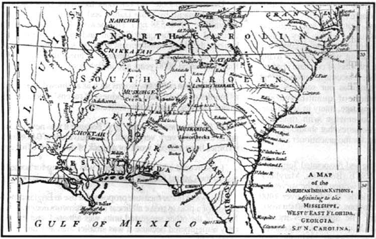
A LINE OF DEMARCATION AND ELLICOTT'S SURVEY OF THE 31st PARALLEL by Gregory Spies On the high seas, as well as in Europe, the war between the French and English continued until the fall of 1762 - the advantage resting almost uniformly with the English. At last, on the 10th of February, 1763, a treaty was ratified at Paris, that put an end to the American intercolonial wars. By its provisions, France gave to England all her possessions in America "east of the Mississippi, from its source to the river Iberville, and through Lakes Maurepas and Pontchartrain to the Gulf of Mexico". Spain, which had also been involved in war with England, ceded East and West Florida to that country in exchange for Havanna, while France gave to Spain Louisiana, whose enormous area, it will be remembered, exceeded that of the whole surrendered territory. In 1781 Don Bernardo de Galvez, Spanish governor of Louisiana, having previously taken Mobile, besieged and captured Pensacola, thus completing the re-conquest of West Florida. Meanwhile, the Revolutionary War was being won on many fronts, and the British were withdrawing. By separate treaties drawn in Paris in 1783, the independence of the U.S. was acknowledged, and West Florida was ceded back to Spain. This provoked a boundary dispute.
To make matters worse, the Spanish authorities issued orders forbidding U.S. citizens to navigate the Mississippi River under "pain of arrest and confiscation of their property". On June 29, 1784 the Spanish foreign minister, the Conde de Florida-Blanca, defined the Spanish definition of the U.S./Spanish West Florida boundary: Beginning at the mouth of the Apalachicola, the line followed by the river Northward to its confluence with the Flint River, thence up the Flint to its source, thence northward in a straight line to the headwaters of the Hiawassee River, thence down the Hiawassee to its confluence with the Tennessee River, thence down the Tennessee to its juncture with the Ohio River, thence down the Ohio to the Mississippi River. The Spanish were, in effect, claiming the vast majority of the territory encompassing the Indian Nations of the Southeast - the Creek, the Cherokee, the Chickasaw and the Choctaw. After many years of turmoil, finally, the Treaty of San Lorenzo el Real, also known as the Pinckney Treaty (1795), was ratified. In it, Spain agreed that U.S. citizens would have the right to free navigation on the Mississippi River and that U.S. citizens would have the right to use the Port of New Orleans for trade. The second article of the treaty addressed the long disputed boundary between Spain and the U.S.. The "line of demarcation" was fixed at the 31st parallel of North Latitude between the Mississippi River and the Chattahoochee River, thence on a line down the Chattahoochee to the mouth of the Flint River, thence on a line to the headwaters of the St. Mary's River, thence down that river to the Atlantic Ocean. The third article stipulated that both Spain and the U.S. would appoint a commissioner and a surveyor to participate in a joint expedition to mark the agreed-upon boundary. George Washington appointed Major Andrew Ellicott and Major Thomas Freeman as Commissioner and Surveyor, respectively. The Spanish King Charles IV appointed the Governor of Louisiana, Baron de Carondolet and Lieutenant Colonel Guillimard. Of the four appointees, Andrew Ellicott was the only one to actually participate in the survey that delineated the 31st parallel. It would take Ellicott and his men almost four years to complete the arduous survey, in the wildest terrain, with very few supplies, and with little encouragement from the localities. A contemporary, Bernard Romans, wrote in 1775: "Travelling through the uninhabited part of the woods, falling to the share of every person, who arrives present in Florida, it cannot be amiss to say a few words about it: whether you go by water or land it is most necessary to carry with you powder, shot, and a fowling piece; provide yourself with rice, or such bread as you like best to use; a hunter is necessary and utensils for dressing provisions; always before night allow yourself at least one hour's time to prepare fire wood, for this must be used in summer as well as in winter to rarify the air round the camp; always lay with your feet to the fire, and you are out of danger of catching cold; if you are in a country where warring savages resort, keep up a large fire all night, and be sure to put some hats on poles near the fire, this will protect you from their attempts, unless they are at war with ourselves...". But Ellicott prevailed; in this time (an abbreviated chronology of the expedition follows), Ellicott made more than four hundred astronomical observations for establishing the boundary. His technique and equipment, far surpassing any others of the period, were meticulous as ever. As Silvio Bedini notes in his Life of Benjamin Banneker: "Ellicott preferred to establish his main encampment on the top of the highest available elevation in the region to be surveyed, and he customarily sought the protection of trees or the edge of a forest for additional protection when possible. The focal point of his operation was the observatory tent, which Ellicott located by tracing a meridian and then laying off an angle from it. It was at this observation point that he set up his large zenith sector and near which he placed his astronomical clock. The clock was a critical factor to all his observations, the one piece of equipment that habitually presented the most problems. It was a precision timekeeper, liable to derangement from many causes. Vibrations from movements upon the ground nearby, changes in temperature, and any contact with it might cause inaccuracy. For this reason he usually set the clock upon the stump of a tree which he had cut down for that purpose. He then erected his observatory tent over the sector and the clock and his other instruments. Other tents for sleeping and for meals were then set up in the vicinity, and an area was provided nearby for tethering the horses." "By far the most important of Ellicott's instruments was the larger of his two zenith sectors, which was nearly six feet long, and by means of which meridional observations were made through an opening in the top of the tent. It had been made for him by David Rittenhouse and he had added his own modifications. It was probably the most accurate scientific instrument in America at that time. It was used for determination of the latitude by observation of stars near the zenith. Observations would be made of six or seven stars as they crossed the meridian at different times of the night, and the observations would be repeated a number of nights over a period of time. Ellicott had remarked in some of his writings that when the stars were so near the zenith they were affected by the different refractive powers of the atmosphere which derived from the varying degrees of density. He found that the error of the visual axis could be reduced to a reasonable minimum by taking zenith distances of the stars with the plane, or face, of the sector alternately facing east or west. The figures derived in this manner were averaged, corrected for refraction, aberration and nutation were applied, and then a comparison was made with the data in published star catalogues. Determination of the latitude was accomplished from this comparison, based on each of the stars observed." The bicentennial of Andrew Ellicott's expedition to run a "line of demarcation" between the United States' Mississippi Territory and Spanish West Florida will begin in September 1996 and will extend through May 2000. To begin the ceremonies, a seminar will be presented in April 1996 (see box article). The focus will be on the social and political events that shaped the survey, Ellicott's journey, his astronomical observations and survey work, all in the context of the original ground and existing monumentation. AN ABBREVIATED CHRONOLOGY OF ELLICOTT'S EXPEDITION TO RUN THE LINE OF DEMARCATION BETWEEN SPAIN AND THE U.S. 1795-1800 10/27/1795 Treaty of San Lorenzo el Real (Pinckney Treaty). Spain & U.S. settle boundary dispute between Florida & U.S. Territory as the 31st parallel of north latitude. 5/4/1796 U.S. President Washington appoints Major Andrew Ellicott as Commissioner to survey & mark the U.S./Spanish boundary. 9/16/96 Ellicott leaves Philadelphia to begin journey to Natchez for meeting with Spanish commissioner & surveyor. 9/28/96 Ellicott arrives in Pittsburgh, where his military escort joins the expedition. 11/25/96 Arrival in Cincinnati. 12/8/96 Arrival in Louis Ville; Ellicott hires a commissary to procure provisions for expedition. 12/17/96 Passes the mouth of the Tennessee River. 12/18/96 Arrival at the mouth of the Ohio River. 2/1/97 Detained overnight on the Mississippi River by a Spanish galley 2/2/97 Detained at Spanish fort at New Madrid for 2 days. 2/8/97 Arrival at Spanish fort at Chickasaw Bluffs. 2/15/97 Detained by Col. Howard, an "Irish gentleman in the service of His Catholic Majesty, who had two armed galleys with him". 2/19/97 Arrival at Walnut Hills where there are "considerable Spanish works". 2/24/97 Arrival in Natchez. Begins lengthy correspondence with Baron de Carondolet and Gayoso concerning the Commencement of the Survey. (Spaniards begin long series of delaying excuses). 3/15/97 Ellicott's military escort arrives at Natchez. Spanish continue to delay. 7/1/97 Inhabitants elect committee to govern the new U.S. territory. 12/1/97 U.S. Army arrives in Natchez. 4/9/98 Ellicott leaves Natchez. 4/10/98 Arrival in Clarksville. 5/2/98 Sets up camp at Alston's Lake. 5/16/98 Commences the demarcation of the boundary. 6/7/98 Moves camp to Little Bayou Sara. 6/10/98 Gov. Gayoso informs Ellicott "of the hostile disposition of the Indians, and their determination to put a stop to the demarcation of the boundary. 6/17/98 Moves camp to Big Bayou Sara. 9/1/98 Moves to Thompson's Creek. 11/17/98 Arrival at the Pearl River. 1/4/99 Takes the Governor's barge to New Orleans. 2/23/99 Gayoso & Ellicott sign 4 reports - 2 in English, 2 in Spanish - confirming all the work done before June 7, 1798. 3/17/99 Arrival in Mobile. 4/20/99 Arrival in Pensacola. 5/8/99 Ellicott rides to Conecuh, sets up camp, and erects observatory. 7/13/99 Ascends the Chattahocha to the Line. 8/23/99 Arrival at the mouth of the Flint River. 9/17/99 Indians attack, horses are stolen, cattle pen is broken down and the Spanish schooner is plundered. Ellicott retreats downriver. 10/7/99 Arrival at St. Mark's (Apalachy). 10/22/99 Arrival in the Keys. 12/9/99 Arrival at the village of St. Simon's (Frederica). 2/7/1800 Party sent to Okefonoke Swamp. 3/3/1800 Astronomical part of boundary complete. 5/1/1800 Arrival in Savannah, sends U.S. schooner Sally to Mobile (Ft. Stoddert) to protect "free navigation" on strategic Mobile River. 5/9/1800 Leaves Savannah for Philadelphia. 5/18/1800 Arrival in Philadelphia. The "Ellicott Stone" is the only known monument set by Major Andrew Ellicott during his survey of the 31st Parallel between Spain and the U.U.. Located on the west side of the Mobile-Tensaw river delta, itself a National Natural Landmark, the stone is 3 feet high, 2 feet wide, and half a foot thick. It is marked on its north side "U.S. Lat. 31 1799" and the south side "Dominos de S.M.C. CAROLUS IV. Lat. 31 1799". In 1803 it became the initial point for "Principal Meridian East of the Pearl River". Today it is known as the St. Stephens Meridian and serves as the basis for all U.S. Public Land Surveys in southern Alabama and southern Mississippi. It is also known as the St Stephens Baseline which today defines the State boundary between Alabama and Florida. It is listed on the National Register of Historic Places and the National Historical Engineering Landmarks. Hopefully, it will soon be placed on the SHS Historical Sites Registry and designated a National Historic Landmark by the National Park Service.
|
|
|