ANALYSIS
OF THE SYSTEM
-----
of -----
United
States Land Surveys
| METES
AND BOUNDS
Up
to the time of the Revolutionary War, or until about the beginning of
the nineteenth century, land, when parcelled out, and sold or granted,
was described by "Metes and Bounds" and that system is still
in existence in the following States, or in those portions of them which
h ad been sold or granted when the present plan of surveys was
adopted: New York, Pennsylvania, New Jersey, Delaware, Maryland,
Virginia, North and South Carolina, Georgia, Tennessee, Kentucky, Texas
and the six New England States. To describe land by "Metes
and Bounds" is to have a known landmark for a place of beginning,
and then follow a line according to the compass-needle (or magnetic
bearing), or the course of a stream, or track of an ancient
highway. This plan has resulted in endless confusion and
litigation, as landmarks decay and change, and it is a well-known fact
that the compass-needle varies and does not always point due North.
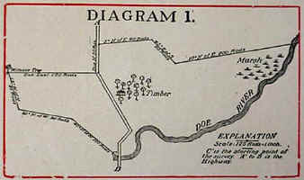
As
an example of this plan of dividing lands, the following description of
a farm laid out by "Metes and Bounds," is given:
"Beginning at a stone on the Bank of Doe River, at a point where
the highway from A. to B. crosses said river (see point marked C. on
Diagram 1); thence 40 degrees North of West 100 rods to a large stump;
then 10 degrees North of West 90 rods; thence 15 degrees West of North
80 rods to an oak tree (see Witness Tree on Diagram 1); then due East
150 rods to the highway; thence following the course of the highway 50
rods due North; then 5 degrees North of East 90 rods; thence 45 degrees
of South 60 rods; thence 10 degrees North of East 200 rods to the Doe
River; thence following the course of the river Southwesterly to the
place of beginning." This, which is a very simple and
moderate description by "Metes and Bounds," would leave the
boundaries of the farm as shown in Diagram 1. |
|
MERIDIANS
AND BASE LINES
The
present system of Governmental Land Surveys was adopted by Congress on
the 7th day of May, 1785. It has been in use ever since and is the
legal method of describing and dividing lands. It is called the
"Rectangular System," that is, all its distances and bearings
are measured from two lines which are at right angles to each
other. These two lines, from which the measurements are made, are
the Principal Meridians, which run North and South, and the Base Lines
which run East and West. These Principal Meridians are
established, with great accuracy. Each Principal Meridian has its
Base Line, and these two lines form the basis or foundation for the
surveys or measurement of all the lands within the territory which they
control.
|
 |
|
Diagram
2 |
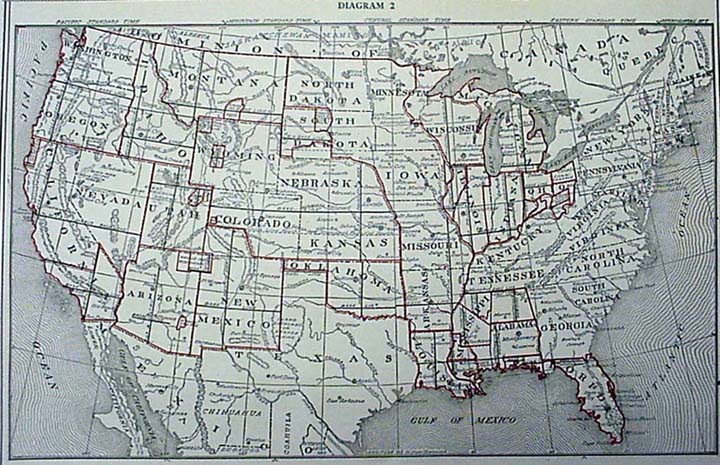
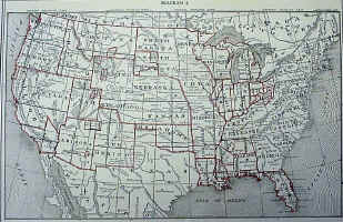
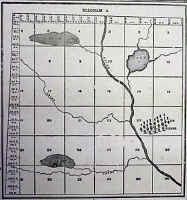
Diagram
2 shows all of the Principal Meridians and Base Lines in the
United States, and from it the territory governed by each Meridian and
Base Line may be readily distinguished. Each Meridian and Base
Line is marked with its proper number or name.
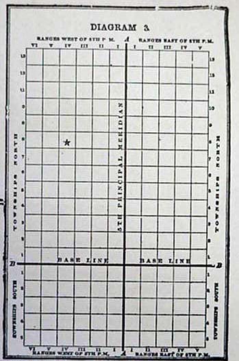
Diagram
3 illustrates what is meant when this method is termed the
"Rectangular System," and how the measurements are based on
lines which run at right angles to each other. The heavy line
running North and South (marked A.A.) on Diagram 3, represents the
Principal Meridian, in this case say the 5th Principal Meridian.
The heavy line running East and West (marked B.B.) is the Base
Line. These lines are used as the starting points or basis of all
measurements or surveys made in territory controlled by the 5th
Principal Meridian. The same fact applies to all other Principal
Meridians and their Base Lines. Commencing at the Principal
Meridian, at intervals of six miles, lines are run North and South,
parallel to the Meridian. This plan is followed both East and West
of the Meridian throughout the territory controlled by the Meridian.
 |
|
Diagram
3 |
These
lines are termed, "Range Lines." They divide the land
into strips or divisions six miles wide, extending North and South,
parallel with the Meridian. Each division is called a Range.
Ranges are numbered from on upward, commencing at the Meridian; and
their numbers are indicated by Roman characters. For instance, the
first division (or first six miles) west of the Meridian is Range I.
West; the next is Range II. West; then comes Range III., IV., V., and so
on until the territory governed by another Principal Meridian is
reached. In the same manner the Ranges East of the Meridian are
numbered, the words East or West being always used to indicate the
direction from the Principal Meridian. See Diagram 3.
Commencing
at the Base Line, at intervals of six miles, lines are run East and West
parallel with the Base Line. These are designated as Township
Lines. They divide the land into strips or divisions six miles
wide, extending East and West, parallel with the Base Line. This
plan is followed both North and South of the Base Line until the
territory governed by another Principal Meridian and Base Line is
reached. These divisions or Townships are numbered from one
upward, both North and South of the Base Line, and their numbers are
indicated by figures. For instance: The first six mile
division North of the Base Line is Township 1 North; the next is
Township 2 North; and so on. The same plan is followed for South
of Base Line as well.
These
Township and Range Lines, crossing each other (as shown in Diagram
3) form squares which are called "Townships" or
"Government Townships," which are six miles square, or as
nearly that as it is possible to make them. These Townships are a
very important feature in locating or describing a piece of land.
The location of a Government Township, however, is very readily found
when the number of the Township and Range is given, by merely counting
the number indicated from the Base Line and Principal Meridian. As
an example of this, Township 8 North, Range 4, West of the 5th Principal
Meridian, is at once located on the square marked with a
"star" on Diagram 3, by counting eight tiers north of the Base
Line and 4 tiers west of the Meridian. |
|
TOWNSHIPS
OF LAND
Townships
are the largest subdivisions of land run out by the United States
Surveyors. In Governmental Surveys Township Lines are the first to
be run, and a Township Corner is established every six miles and
marked. This is called "Townshipping." After the
Township Corners have been carefully located, the Section and Quarter
Section Corners are established. Each Township is six miles square
and contains 23,040 acres, or 36 square miles, as near as it is possible
to make them. This, however, is frequently made impossible by
(1st) the presence of lakes and large streams; (2nd) by State boundaries
not falling exactly on Township Lines; (3rd) by the convergence of
Meridians or curvature of the earth's surface; and (4th) by inaccurate
surveys.
 |
|
Diagram
4 |
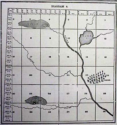
Each
Township, unless it is one of the exceptional cases referred to, is
divided into 36 squares, which are called Sections. These Sections
are intended to be one mile, or 320 rods, square and contain 640 acres
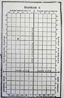
of land. Sections are numbered consecutively from 1 to 36, as
shown on Diagram 4. Beginning with Section 1 in the
Northeast Corner, they run West to 6, then East to 12, then West to 18,
and so on, back and forth, until they end with Section 36 in the
Southeast Corner.
Diagram
4 shows a plat of a Township as it is divided and platted by the
government surveyors. These Townships are called Government
Townships or Congressional Townships, to distinguish them from Civil
Townships or organized Townships, as frequently the lines of organized
Townships do not conform to the Government Township lines. |
|
SECTIONS
OF LAND
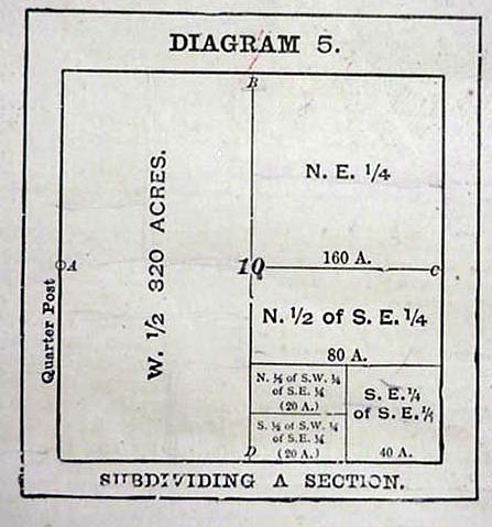
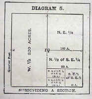
Diagram
5 illustrates how a section may be subdivided, although the
Diagram only give a few of the many subdivisions into which a section
may be divided. All Sections (except Fractional Sections) are
supposed to be 320 rods, or one mile, square and therefore contain 640
acres--a number easily divisible. Sections are subdivided into
fractional parts to suit the convenience of the owners of the
land. A half-section contains 320 acres; a quarter-section
contains 160 acres; half of a quarter contains 80 acres, and quarter of
a quarter contains 40 acres, and so on. Each piece of land is
described according to the portion of the section which it embraces--as
the Northeast quarter of Section 10; or the Southeast quarter of the
Southeast quarter of Section 10. Diagram 5 shows how many of these
subdivisions are platted, and also shows the plan of designating and
describing them by initial letters as each parcel of land on the Diagram
is marked with its description.
 |
|
Diagram
5 |
As
has already been stated, all Sections (except Fractional Sections) are
supposed to contain 640 acres, and even though mistakes have been made
in surveying, as is frequently the case, making sections larger or
smaller than 640 acres, the Government recognizes no variation, but
sells or grants each regular section as containing 640 acres "more
or less."
The
Government Surveyors are not required to subdivide sections by running
lines within them, but they usually establish Quarter Posts on Section
Lines on each side of a section at the points marked A. B. C. and D. on Diagram
5. After establishing Township corners, Section Lines are
the next to be run, and section corners are established. When
these are carefully located the Quarter Posts are located at points as
nearly equidistant between Section Corners as possible. These
corners when established by Government Surveyors cannot be changed, even
though it is conclusively shown that mistakes have been made which cause
some sections or quarter sections to be either larger or smaller than
others. The laws, however, of all the States provide certain rules
for local surveyors to follow in dividing Sections into smaller parcels
of land than has been outlined in the Governmental surveys. For
instance, in dividing a quarter section into two parcels, the distance
between the Government Corners is carefully measured and the new post is
located at a point equidistant between them. This plan is followed
in running out "eighties," "forties,"
"twenties," etc. In this way, if the Government division
overruns or falls short, each portion gains or loses its
proportion. This is not the case, however, with Fractional
Sections along the North or West sides of a Township; or adjoining a
lake or large stream. |
|
FRACTIONAL
PIECES OF LAND
Congressional
Townships vary considerably as to size and boundaries. Mistakes
made in surveying and the fact that Meridians converge as they run North
cause every Township to vary moreor less from the 23,040 acres which a
perfect Township would contain. In arranging a Township into
Sections all the surplus or deficiency of land is given to, or taken
from, the North and West tiers of Sections. In other words, all
Sections in the Township are made full--640 acres--except those on the
North and West, which are given all the land that is left after forming
the other 25 Sections.
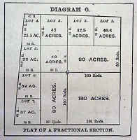
Diagram
4 illustrates how the surplus or deficiency is distributed and the
Sections 1 thru 7, 18, 19, 30 and 31 are the "Fractional
Sections," or the Sections which are affected if the Township
overruns or falls short. Inside of these Fractional Sections, all
of the surplus or deficiency of land (over or under 640 acres) is
carried to the "forties" or "eighties" that touch
the Township Line. These pieces of land are called
"Fractional Forties" or "Fractional Eighties" as the
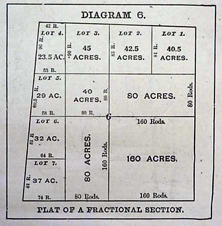
case may be. Diagram 4 and 6 show the manner of marking the
acreage and outlining the boundaries of these "Fractions."
 |
|
Diagram
6 |
Diagram
6 illustrates how the surplus or deficiency of land inside of these
Sections is distributed and which "forties" or
"eighties" it affects. From this arrangement it will be
seen that in any Section that touches the North or West Township Lines,
the Southeast Quarter may be full--160 acres--while another quarter of
the same Section may be much larger or smaller. Frequently these
fractional "forties" or "eighties" are lotted as
shown in Diagram 6. They are always described as fractional tracts
of land, as the "fractional S. W. 1/4 of Section 6,"
etc. Of course those portions of these Sections which are not
affected by these variations are described in the usual manner--as
Southeast 1/4 of Section 6. As a rule Townships are narrower at
the North than at the South side. The Meridians of Longitude
(which run North and South) converge as they run North and South from
the Equator. They begin at the Equator with a definite width
between them and gradually converge until they all meet at the
poles. Now, as the Range lines are run North and South, it will at
once be seen that the convergence of Meridians will cause every
Congressional Township (North of the Equator) to be narrower at its
North than at its South side, as stated. See Diagram 4. In
addition to this fact, mistakes of measurement are constantly and almost
unavoidably made in running both Township and Range lines, and if no new
starting points were established the lines would become confused and
unreliable, and the size and shape of Townships materially affected by
the time the surveys had extended even a hundred miles from the Base
Line and Principal Meridian. In order to correct the surveys and
variations caused by the difference of latitude and straighten the
lines, "Correction Lines" (or Guide Meridians and Standard
Parallels) are established at frequent intervals, usually as
follows: North of the Base Line a Correction Line is run East and
West parallel with the Base Line, usually every twenty-four miles.
South of the Base Line a Correction Line is usually established every
thirty miles. Both East and West of the Principal Meridian
"Correction Lines" are usually established every 48
miles. All Correction Lines are located by careful measurement,
and the succeeding surveys are based upon them. |
|