![]()
![]()
![]()
|
|
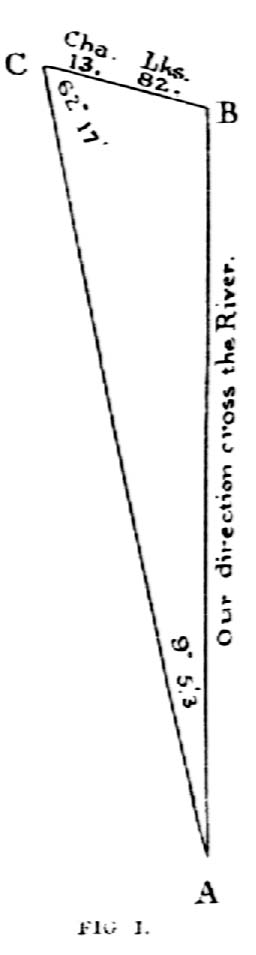
DISTANCE ACROSS A RIVER by Wilhelm A. Schmidt, PLS The first leg of Lewis and Clark’s epic journey was down the Ohio River. They encamped for a week at its confluence with the Mississippi. Meriwether Lewis made astronomical observations as he had learned from Ellicott. Stephen E. Ambrose, in his Undaunted Courage, writes that Lewis had been discouraged from taking along surveying equipment. But William Clark had apparently brought his, and used it to good effect during their encampment. "With his measuring chain and circumferentor, or surveying compass, Clark determined by triangulation that the width of the Ohio at this point just before juncture was 1,274 yards, that of the Mississippi 1,435 yards, and of the combined rivers 2,002 yards." (p.119) A surveyor back then could measure anything with a compass and a chain, as long as there was nothing in his way. Even if there was, he could traverse around it, as long as he had ground under his feet. But when ground forsook him, he had to resort to ... triangulation. Ambrose does not tell us how Clark did it. Thomas Pynchon, in Mason & Dixon, is more forthcoming. When Charles Mason and Jeremiah Dixon came to the Susquehanna, they had to get the distance across it in order to resume the chaining on the other side. The way Dixon had supposedly learned to do it back in Durham was "to measure out a Base Line upon the further Bank, set up there, turn off ninety degrees, put a mark on the near side, come back across, set up a mark there, and find the angle between the two ends of the Base Line, - then with the aid of a book full of logarithms, including those of "Trig" functions, ‘twould take but a minute and a half of adding and checking to find the distance across the River." (p. 461-62) All he would have to do is multiply the length of the baseline by the cotangent of the measured angle - or to add their logs and look up the distance. But Pennsylvania is not Durham. Back home, there were "nowhere near this d ‘d many Trees." After "kicking up clouds of Gnats, crushing wild Herbs in Blossom, seeking a line of sight that will allow them to use a Right Angle [proved to be] a Fool’s Errand." All they could do was obtain "at last an ungainly Oblique Triangle, from which they calculate Susquehanna to about seven-eights of a mile across." "About seven-eights of a mile" is hardly better than an educated guess. Surely, Dixon determined the distance more accurately than that. But Mason & Dixon is a novel, not an historical account, interested in portraying the hardship of making the measurements more than conveying the resulting numbers. More to the point, Dixon had to stay on a line which likely was not perpendicular to the river. He was not really concerned with the width of the river anyway, but with the distance between points on a line on opposite sides of the river. By contrast, Clark wanted, for the record, to determine the widths of the rivers, and could do his measurements at spots convenient for that purpose. The fact remains that Dixon had to resort to a more complicated procedure. We are told only that he had to make the calculations by means of an "oblique" triangle. But that is all we need to know to understand how he might have done it. In the simpler case, one side and two angles are known. One of the angles is a right angle. In the more complicated case, this angle is acute or obtuse. In that case, the baseline can be established along either side of the river, the two angles measured from both ends of the baseline to the same point on the other side of the river, and the third angle calculated simply by subtracting the sum of the two angles from 180 degrees. The trick is then to apply the law of sines. This law states that the sines of the angles of a triangle are proportional to the lengths of the sides opposite the angles (sine a: side A::sine b: side B::sine c: side C). Already knowing the three angles and one side, it is possible to calculate the other two sides - one of which is the distance between the two points along the surveyed line. We still don’t have the perpendicular distance across the river, but it is now also easy enough to calculate. The distance is the height of the triangle. We only have to multiply the length of one of the calculated sides - it doesn’t matter which - by the sine of the angle formed by it and the baseline. In actuality, perhaps these adventuresome men used still another variant of this procedure. We can always consult their journals - instead of a history book and a novel - to get descriptions of their actual procedure.
|
|
|